Funding in Place for Katahdin Region Recreational Wayfinding
The arrival of fresh wayfinding signs in Millinocket, Maine, in fall 2022 represented phase one of a cooperative effort to improve resident and visitor experiences in Maine’s Katahdin region. Over the past year, the Center has worked with partners to plan and secure funding for a phase-two buildout of a regional recreational wayfinding system in spring 2024.
 The new wayfinding system encompasses more than 120 signs to guide people to recreational amenities across the Katahdin region – including the communities of Millinocket, East Millinocket, Medway, Sherman, Stacyville, Patten, Island Falls, Mount Chase and adjacent unorganized territories.
“Good wayfinding guides people to places that are ready for public use and helps reduce pressure and impact on private lands and places that don’t have the infrastructure for heavy use,” said Mike Wilson, Senior Program Director for the Center. “It enables higher quality and more sustainable recreational experiences for visitors and local residents.”
The Maine Department of Transportation, local municipalities, businesses, and non-profits provided input on the design for the signage system, and USDA Rural Community Development funded the design and planning. Other partners in the project included the Outdoor Sports Institute and the Katahdin Tourism Partnership.
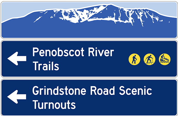 The project grew from recognition of there was no consistent signage directing people to the Katahdin region’s outstanding recreational amenities including Baxter State Park, the new Katahdin Woods and Waters National Monument, Penobscot River Trails, and a vast array of snowmobile and off-highway trails that crisscross the region, community trail systems, and a multitude of lakes and waterways. The 2019 Katahdin Gazetteer: A Roadmap to the Future identified wayfinding as a priority for the region.
“We are thrilled to have improved wayfinding signage in our region,” said Tracey Perry, initiatives director for Katahdin Collaborative. “Not only will it improve visitor experience contributing to increased accessibility, it will also promote community engagement fostering community pride.”
The sites included in the project range from major amenities like Katahdin Woods and Waters National Monument, to snowmobile parking areas and community parks. Signage includes everything from large vehicular directional signs to smaller point of interest signs and directions to parking areas.
The signage system itself uses multiple design images to highlight and honor the different views of Mt. Katahdin – the region’s defining landmark – from different parts of the region.
In August, the Penobscot County Commissioners awarded funding to the Center to support fabrication and installation of the new wayfinding system. The Center is beginning to coordinate installation efforts with local municipalities.